Support us from £3/month
We deal with almost 1000 cases a year assisting communities, groups and individuals in protecting their local spaces and paths in all parts of England and Wales. Can you help us by joining as a member?
We are celebrating the addition of a 2.3-kilometre restricted byway to the official map of public paths in East Sussex. The route was claimed, based on historical evidence, by our local correspondent for Lewes, Chris Smith.
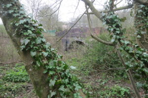
Wootton Bridge is one of the spots on the route our local correspondent has claimed in East Sussex. Photo: Open Spaces Society
The path runs from Robin Post Lane in the north (to the west of the A27 between Hailsham and Polegate), south to cross a bridleway which is part of Sustrans national cycle route 2 (which runs along the south coast), then to Hide Cottage before descending to the A27 from where it is possible to access the new cycle route from Lewes to Polegate.
Chris did copious research to prove that the route was a public highway, and East Sussex County Council, the surveying authority, did more. The council made an order for the path, but the landowner objected and so the matter was referred to a planning inspector to determine after exchanges of written representations.
On 9 August, inspector Gareth W Thomas ruled that the path was a public highway and should be added to the definitive map as a restricted byway [1].
He commended the evidence submitted by the applicant and the objectors as ‘very comprehensive’. He reviewed this evidence, and considered that the records relating to the railway, which is crossed by the path at its southern end, were decisive. The Railway Acts allowed for compulsory purchase of land to build railways, and although they were not produced to record public rights of way, the plans needed to be accurate. The railway plans for this site, of 1839 and 1843, stated that part of the claimed route is a parish road, and subsequent documents confirmed that. There was a dispute about the precise alignment, but the inspector agreed with Chris Smith that the route he now claimed was shown in the 1877 highway-diversion plan.
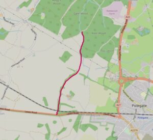
This map shows the newly claimed route in red.
Says Chris: ‘This route runs through an area with no public rights of way, and so will be a useful addition to the network, linking footpaths and bridleways around Abbots Wood and those on the South Downs.
‘The way is not open and usable yet because the northern section has become overgrown, but once East Sussex County Council has carried out the necessary work, it will be available for walkers, horse-riders, cyclists and carriage drivers, and will be a great asset to them.
‘However, it is deeply worrying that routes such as these, if not claimed, could be lost when the government implements the guillotine on the addition of historic ways for the definitive map. That cut off is set at 2026 although is likely to be extended until 2031—still not long enough for the huge amount of work that needs to be done to get our definitive maps up to date.’
[1] The decision letter from Gareth W Thomas is dated 9 August 2023, ref ROW/3293515.