
Support us from £3/month
We deal with almost 1000 cases a year assisting communities, groups and individuals in protecting their local spaces and paths in all parts of England and Wales. Can you help us by joining as a member?
We are celebrating the recognition of an ancient public footpath from Eastry to Hammill in East Kent.
In August 2022, the society applied to Kent County Council to record a public footpath between Gore Lane, Eastry, and Hammill Farm,[1] a distance of 1,600 metres across the arable lands west of Eastry village. This area lacks any recorded rights of way save a solitary byway open to all traffic. The application was founded in historical evidence of reputation, including a map of Danecourt Farm, then belonging to the Hospital of St Thomas in Sandwich, thought to date from the early eighteenth century.
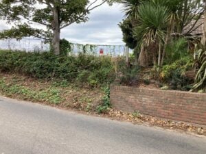
The footpath’s termination on Gore Lane, Eastry. Photo: The Open Spaces Society
The county council granted the application, and expedited making a definitive map modification order because of the residential development adjoining Gore Lane in Eastry. Nigel Farthing LLB, an inspector of the Secretary of State for Environment, Food and Rural Affairs, now has confirmed the order, following objections, in a decision dated 11 September 2026.
Hugh Craddock, one of our case officers who researched the application in a voluntary capacity, said: ‘I am delighted that this footpath is being added to the definitive map and statement. It is just one of a number of paths across Eastry’s arable fields which were seemingly intentionally left off the parish map of public paths which Eastry parish council was required to draw up in the early 1950s.
‘Through the combined voluntary efforts of the Society and the British Horse Society, this footpath, EE487, bridleways EE488, EE490 and EE491, bridleway EE226A (upgraded from footpath), and restricted byways EE493 and EE499, have been added to the map, but sadly many more have been lost, perhaps for ever, because the post-war parish council prioritised farming over public access.’[2]
Hugh added: ‘Getting the footpath back on the map is only the first step. Fortunately, we understand that the development at Gore Lane will leave a margin for the footpath, but work must be done to reinstate a crossing of the old East Kent Light Railway cutting. Perhaps today’s parish council would like to spearhead efforts to get all these paths reopened as valuable additions to the recreational network?’
[1] The way begins at Gore Lane, Eastry, opposite the junction with footpath EE252A (OS grid reference TR30575500) and leads generally west-northwest to terminate at a junction with Chalkpit Lane, Hammill (TR29095546). Further details available here.
[2] Some evidence for the council’s perspective is reflected in the minutes of a meeting held on 1 March 1954, in relation to what is now recorded as bridleway EE382 (a bridleway between Hay Hill and Updown, which was omitted from the Eastry parish map). It seems the parish council was asked to reconsider its omission of the bridleway.
‘Bridle Road No.7. In reply to a letter from the Divisional Surveyor, Mr B G Longmore regarding the Bridle Road No.7 retained by the Northbourne Parish Council in the Draft Map prepared by them, it was proposed by Mr J Bones, seconded by Mr B D Gillman that the interest of the Council remains only in the continuance of the Parish Boundary which is in fact the centre line of the Bridle Road. The Bridle Road had served no useful purpose for many years as a road and was brought under cultivation during the recent war. The Council did not therefore include it in the Draft Map for the Parish. Further it was much regretted that the road should be marked by stones which would cause great inconvenience to farm management.’
(Eastry parish council minute book 1953–60, p.20.)