Support us from £3/month
We deal with almost 1000 cases a year assisting communities, groups and individuals in protecting their local spaces and paths in all parts of England and Wales. Can you help us by joining as a member?
Our newly-appointed local correspondent for Rochdale, Yvonne Hunt, looks at the threat to public paths in her area, including the Rochdale Way.
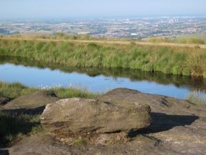
View of Rochdale from the Rochdale Way
The Rochdale Way and parts of its connecting network of paths are under threat by developers who do not seem to understand their importance. The Rochdale Way is a circular 45-mile (72-km) walking route around the borough of Rochdale which takes in some of its best scenery and most interesting buildings. The area covered includes Hollingworth Lake, Blackstone Edge on the Pennine Way, Watergrove Reservoir, Healey Dell, Knowl Hill, Naden Valley and much more.
The way is broken down into sections as the majority of people would prefer not to walk the whole 45 miles in one day. It crosses the M62 motorway at two points, on the east side at Rakewood Viaduct, and on the west side at junction 19. A new slip road is planned at this junction and it is unclear how this will affect the Rochdale Way and other paths.
The whole area is rich in history, from the early silk-weavers to the mighty mills of the cotton-weaving industry; the evidence is there to be discovered.
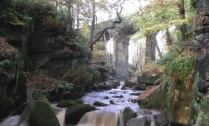
Healey Dell
I believe firmly that development should not be allowed to reduce the accessibility to rights of way nor to wipe away the history and early development of an area which is our heritage and of which we are proud.
Rights of way help to boost tourism and contribute to rural economies, they are important for fresh air and exercise. Local authorities should regard them as an integral part of the transport network and should care for them, not promote their destruction.